EOForChina researchers have evaluated the potential of Sentinel-3 radar altimetry for monitoring China's rivers in a
new study recently published in Remote Sensing of Environment.
Satellite altimetry has been widely used for ocean-related studies. But it is still new and challenging for inland water studies. One of the main reasons is the on-board tracking system, which controls when the antenna should listen. In other words, to a great extent, the tracking system determines whether altimetry can record signals reflected from rivers. Previous missions, such as Envisat, Jason-1/-2, CryoSat-2, SARAL/AltiKa, etc. use closed-loop tracking function, which has problems to detect rivers, especially over rugged topography. However, these poorly gauged regions are the areas where satellite altimetry has the highest value.
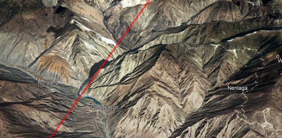
Figure 1. Demonstration of a ground track (red line) of Sentinel-3A across the upper stream of the Lancang river
To address this problem, an open-loop function is used on-board Sentinel-3. In open-loop mode, the altimeter can set the tracking window according to pre-defined a-priori elevation of river targets. Therefore, the a-priori information is key to this tracking function.
Sentinel-3A has been operating since July 2016. How does it work for rivers? Could we obtain useful data for mountainous rivers? In our latest study, we evaluate Sentinel-3A at 50 virtual stations over different Chinese rivers (Figure 2). Our results indicate that during the first nearly three years (July 2016 to February 2019), Sentinel-3A did not deliver useful data over many mountainous revers due to the low quality of OLTC V4. Since the update of OLTC in March 2019, data quality has been significantly improved by using OLTC V5. This has great implication for upcoming Sentinel-6/Jason-CS, Sentinel-3C/-3D, etc.
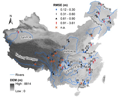
Figure 2. Sentinel-3A performance in terms of RMSE of retracked heights against in-situ records. Note that, the best RMSE is used among three (four if available) retrackers.
In addition, surroundings are also very important to derive accurate L2 WSE. For example, Figure 3 shows the complex surroundings along the Yangtze river. Due to the large footprint, a waveform over the river is often contaminated by other water bodies. Therefore, high uncertainty presents in the WSE time series. In this study, we applied a dedicated retracker MWaPP+ to address this issue.
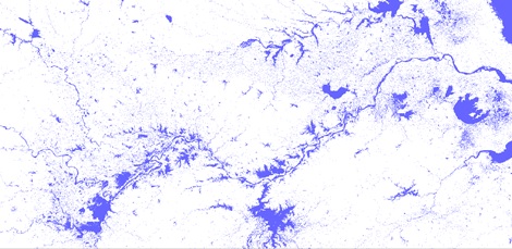
Figure 3. A snapshot from the Global surface water explorer showing the complex surroundings along the Yangtze river.
The MWaPP+ assumes all waveforms contain a peak reflected from the river, then by finding the common peak, MWaPP+ can retrack the one corresponding to the river surface instead of other water bodies. As shown in figure 4, compared to other retrackers, MWaPP+ can significantly improve L2 WSE for the Yangtze River. In many cases, other three retrackers give a false river WSE by retracking the peaks reflected by other water bodies.
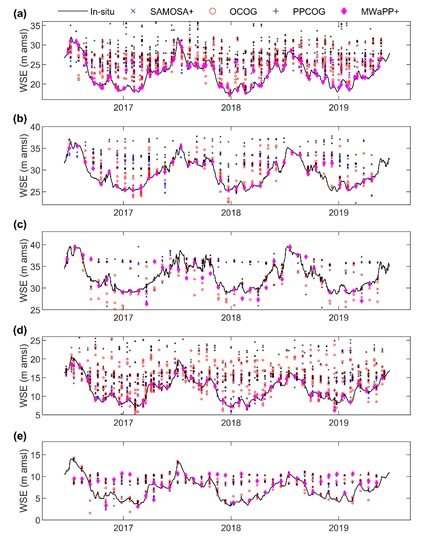
Figure 4. Comparison of WSE retracted by four methods and gauged water level at five VSs located along the Yangtze River. (a) - (e) correspond to VS 18 - 20, 25 - 26. Note that, individual retracked WSE is shown for SAMOSA+, OCOG, and PPCOG.
The paper describing all the details has just been published in Remote Sensing of Environment. Please contact Liguang Jiang if you are interested in a postprint of the article. This study will support our further work for EOForChina project to deliver high quality of WSE for many virtual stations.