Sentinel-3 has become a major resource supplementing in-situ records of river, lakes, and reservoirs. Configurated in a constellation of two identical altimeters, Sentinel-3 provides higher spatial coverage and temporal resolution. Beyond that, Sentinel-3 is fully operated in SAR mode and configurated with the Open-loop tracking mode. All these features are expected to greatly improve data quantity and quality. This should greatly help us monitor inland water dynamics from space.
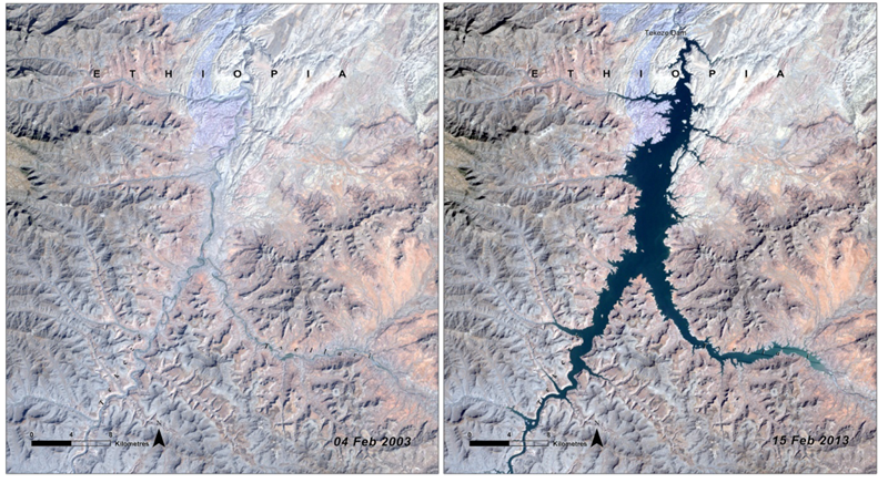
Figure 1. Reservoir behind the Tekezé Dam (Images credit: UNEP)
Particularly, reservoirs play an important role in water resources management, hydropower generation, flood control, etc. and have gained increasing attention especially in transboundary river basins. In our latest accepted paper, we evaluate the capability of Sentinel-3A over newly built reservoirs (since 2005). Unfortunately, data quality is insufficient over many reservoirs, especially reservoirs that have been constructed recently. We investigated the reasons for the performance problems and found an issue with the on-board a-priori elevation that is used by the Open-loop tracking system. As illustrated in figure 2a, the range window (solid line indicates portion above, dotted line the portion below the water surface) is positioned correctly. Therefore, the altimeter is able to record reflected echoes from water, and a full waveform (upper-right plot, spanning 60 m) is acquired. However, after dam construction (figure 2b), on-board a-priori elevation does not represent ground truth anymore. Therefore, the range window is positioned too low (too late in time) to record echoes returned from water surface. Depending on the rise of water surface elevation after dam construction, the recorded signals could be the trailing edge of the waveform or just background noise.
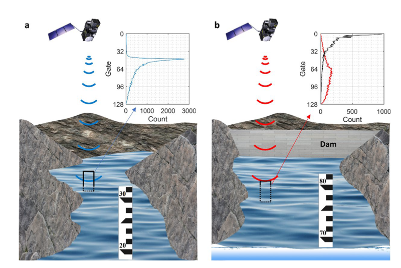
Figure 2. Illustration of the range window position before and after the construction of a dam.
To handle this issue, we suggested four approaches to determine better a-priori elevations for these reservoirs. In the best case, we should use available Sentinel-3 observations that are acquired in closed-loop in the commissioning phase. Alternatively, we can use CryoSat-2 and AltiKa-DF observations, which are densely distributed due to the drifting ground track. These two datasets can greatly improve knowledge of reservoir elevation in recent decade. We also suggest using open-source information, such as dam database and global DEM to provide a-priori information of reservoirs.
By ensuring the on-board a-priori elevation is correct, data quality can be greatly improved, and provide added value to the hydrological community. The approaches can also help to determine a-priori elevation for current and future altimetry missions, such as upcoming Sentinel-6, SWOT, etc.
This study will be published in Geophysical Research Letters and will support our future work in EOForChina to deliver high quality of WSE for many virtual stations over the transboundary rivers in China.