The Nu rises at 5,450 metres in the Tanggula Mountains on the Tibetan Plateau, near the headwaters of the Mekong and Yangtze rivers. It initially flows west but then very shortly makes a great bend to the east, entering the Chinese province of Yunnan and the Three Parallel Rivers of Yunnan Protected Area, a World Heritage Site.

Figure 1. Map of the river system in the Nu River basin, Southwest China
Many of the natural resources in the Nu River basin remained unexploited until the twentieth century. Prior to extensive logging activity in the upper watershed, the Nu's flow varied much less between the rainy and dry seasons, allowing for fertile riverbanks to be fed by soil deposits from the river. With the clear-cutting of the forests, soil began to erode away in great amounts and was unable to hold water, thus lowering the river's baseflow during the dry season and causing floods of greater size during the monsoon. The erosion has also made the Nu very silty. China attaches great importance to the protection of the Nujiang River. We have also monitored the Nu River for a long time. The following picture shows the changes in the water level of the Nu River from 2018-06 to 2019-01. As shown in Figure 2, the high water level in July is a period of high flood occurrence.
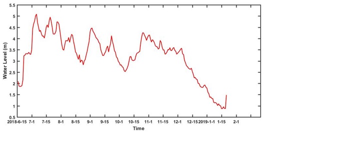
Figure 2. Observed water level at Nu River basin from 2018-06 to 2019-01